


Transportation Management System
Transportation Management System
Public Transport Operations
A smart public transport management system, GIS-based and supported by web and PWA (Progressive Web App), that manages municipalities’ public transport services through a single central platform via lines, stops, fleet, ticketing, live vehicle tracking, density analysis, citizen portal, and decision-support modules.
OverviewHow It Works
How Transportation Management System Works
Municipalities’ public transport services form a comprehensive operational domain that runs many processes simultaneously, such as line planning, stop management, fleet operations, driver assignments, ticketing, citizen information, and auditing. Transportation Management System manages these processes under nine operational dimensions on a single central platform.
Transportation Management SystemTransportation Management System
Transportation Management System · Transportation Management SystemGIS-Based20 ModulesPWA-SupportedSingle-Installation ArchitectureOpen-Source Technology
Overview
Manage Your Public Transport Processes on a Single Platform with Transportation Management System
Transportation Management System is a smart public transport management system, GIS-based and accessible via web and mobile, that enables municipalities to manage their public transport services through a single central platform. It offers 20 different modules in a single integrated structure, from line and stop management to live vehicle tracking, from fare and tariff definitions to density analysis, and from the citizen portal to AI (Artificial Intelligence) supported frequency recommendations.
★
Transportation Management System
360°
delivers end-to-end public transport management
With a municipality-based single-installation (single-tenant) architecture, each municipality’s data is kept on its own server. Line, stop, trip, fleet, ticketing, live tracking, and citizen portal processes are tracked in the same data structure.
♦
Highlights
Map and Geographic Information System (GIS)
Lines, stops, routes, and fleet movements are displayed on the map.
With PostGIS, GDAL/OGR, and NetTopologySuite infrastructure, data can be uploaded in Shapefile, DWG, GeoJSON, and GML formats; support for 18 different EPSG (European Petroleum Survey Group — coordinate system standard) coordinate systems is provided.
Format85%
EPSG90%
AVL (Automatic Vehicle Location)
The vehicle fleet’s location is obtained via the HTTP pull method through the Arvento AVL service.
It is broadcast at 5–15 second intervals via the SignalR WebSocket infrastructure. Clients subscribe by line IDs and track only the relevant vehicles.
5–15 sn95%
3 Hub80%
Decision Support and Artificial Intelligence
The FrekansOneriWorker background worker generates analysis and optimization recommendations.
By analyzing the OD Matrix (Origin-Destination passenger flow matrix), peak-hour demand, capacity utilization, and seasonal patterns, it generates trip frequency optimization recommendations. The recommendations are presented directly on the manager dashboard.
Analiz85%
Worker90%
Capabilities
The Public Transport Operation Flow
Managed from Start to Finish
- 01.Lines and RoutesDefinition of bus/minibus lines (code, name, color, start-end stop), outbound/return variants, LineString route geometry on the map, and a data model compliant with GTFS (General Transit Feed Specification).
- 02.Stop and Zone ManagementGPS location of stops, accessibility, and signage status; line-stop relationships and sequence information; definition of transport zones as polygons; bus depots and capacity information.
- 03.Trip PlanningTrip definition based on line variant, vehicle, driver, start-end time, and estimated number of passengers; performance analysis of completed trips.
- 04.Fleet, Driver, and Assignment ManagementVehicle plate, brand, model, type, and capacity information; periodic maintenance, inspection, and insurance tracking; driver ID, license, shift start-end and rest periods; vehicle-line and vehicle-driver assignments.
- 05.Live Vehicle Tracking (AVL)Vehicle location data (latitude, longitude, heading, speed, plate) obtained via the HTTP pull method through Arvento AVL integration is broadcast at 5–15 second intervals via the SignalR WebSocket infrastructure. Location history is stored in the database as a time series.
- 06.Density Analysis and ETA (Estimated Time of Arrival)Real-time density calculation (0–100%); hourly, daily, weekly historical and comparative analysis; geographic heat map. Stop-based ETA calculation: Distance / Average Speed + Stop Waiting Time. Results are transmitted to clients via SignalR.
- 07.Smart Card and Fare ManagementCard transactions (boarding/alighting, amount paid, timestamp); automatic trip-card matching with KartIslemMatchWorker; line-based tariff definition (time range, day range); card type management (full, student, 60+, transfer).
- 08.Decision Support and Frequency RecommendationThe FrekansOneriWorker background worker analyzes the OD Matrix (Origin-Destination), peak-hour demand, capacity utilization, and seasonal patterns to produce a comparison of current vs. recommended frequency; the recommendations are presented on the dashboard.
Core Capabilities
Modules that support Transportation Management System operations
The infrastructure modules that form the backbone of the system feed the operational workflow end-to-end.
Go to OverviewONLINE
Map and GIS (Geographic Information System) Module
Layer management, SLD (Styled Layer Descriptor) based styling, data upload in Shapefile / DWG / GeoJSON / GML / NCZ formats, map sketching, pin and bookmark management, mini map, and gazetteer (geographic name search) capabilities.
AVL
Live Vehicle Tracking (AVL) Module
Vehicle location data retrieval via the HTTP pull method through the Arvento API; broadcast to clients at 5–15 second intervals via SignalR WebSocket. Line-based subscription, location history, and a mock data generator (for the development environment) infrastructure.
AI
AI-Supported Frequency Recommendation Module
FrekansOneriWorker analyzes passenger flow (OD Matrix), peak-hour demand, capacity utilization, and seasonal patterns to produce a comparison of current vs. recommended frequency along with its justification. It is displayed on the dashboard.
Capability Cards
Transportation Management System’s Main Modules,
in a Single Platform
Transportation Management System’s main modules are organized as concise corporate summary cards.
MAP · GIS
Map and GIS
PostGIS infrastructure, 18 EPSG coordinate systems, Shapefile / DWG / GeoJSON / GML data upload, SLD styling, map sketching, pin and bookmark management.
LINE MANAGEMENT
Line and Route Management
Line code, name, color, variants; outbound/return routes; LineString geometry on the map; GTFS-compliant data model (routes, trips, stops, shapes).
STOP
Stop and Zone Management
Stop GPS location, accessibility, signage status; line-stop relationship and sequence; definition of transport zones as polygons; depot management.
LIVE TRACKING
Live Vehicle Tracking (AVL)
HTTP pull integration with Arvento AVL; location broadcast every 5–15 seconds via SignalR; latitude, longitude, heading, speed, plate information; line-based subscription.
ETA
Estimated Time of Arrival (ETA)
Stop-based ETA calculation (Distance / Average Speed + Stop Waiting); automatic update as vehicles move; stop ID-based SignalR subscription.
DENSITY
Density Analysis
Real-time occupancy (0–100%); hourly / daily / weekly comparison; geographic heat map; continuous data collection and calculation with YogunlukAggregateWorker.
SMART CARD
Smart Card and Fare
Card transactions (boarding/alighting records); trip-card matching with KartIslemMatchWorker; line-based tariff; full, student, 60+, transfer card types.
CITIZEN
Citizen Portal (PWA)
Line, stop, and tariff information; live vehicle tracking; announcement and FAQ management; contact form; SMS-verified request submission; PWA-supported mobile experience.
Resources
Explore our promotional materials
You can access presentation and promotional content about Transportation Management System from this section.
PDF
Transportation Management System Presentation File
A promotional file summarizing the product’s 20-module structure, technical infrastructure, integration points, and municipal use cases.
View PresentationVideo
Transportation Management System Promotional Video
A promotional video covering how the system works, including the management panel, line management, live vehicle tracking, and citizen portal screens.
Watch VideoProduct Tour
Explore Transportation Management System
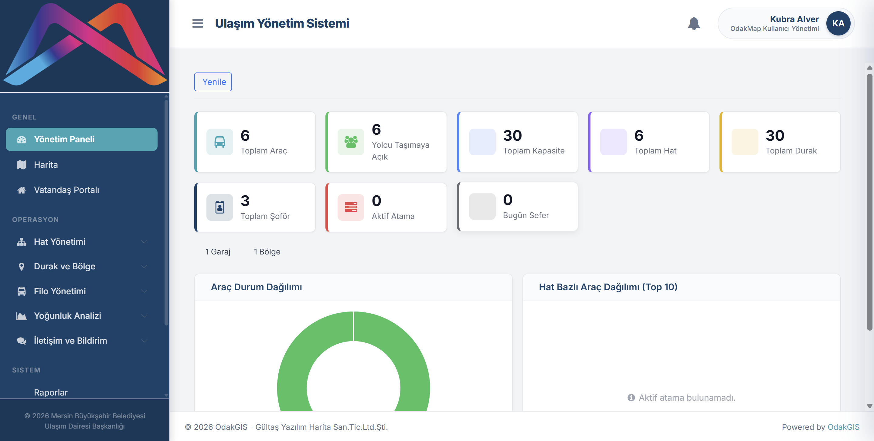
Management Panel (Dashboard)
The Transportation Management System management panel presents core KPIs (Key Performance Indicators) on a single screen, such as total vehicles, number of vehicles open to passenger service, total capacity, total lines, total stops, total drivers, active assignments, and the number of trips for the day. Vehicle status distribution (donut chart) and line-based vehicle distribution (Top 10) visualizations form the main panel of the management decision-support infrastructure.
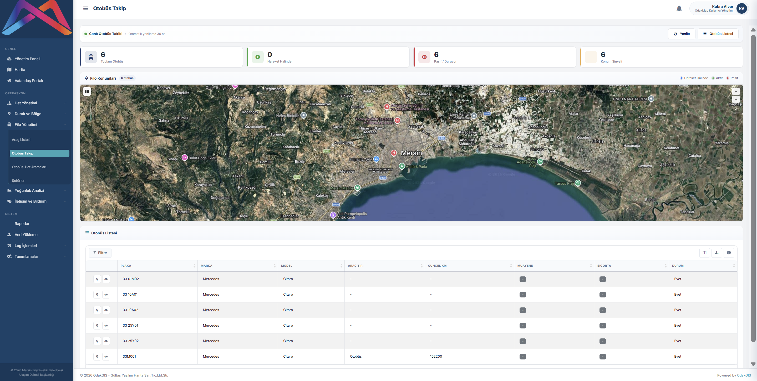
Live Vehicle Tracking (AVL)
On the live bus tracking screen, the real-time positions of vehicles on the map, plate and line information, driver information, and speed and heading data are monitored. Locations obtained through Arvento AVL integration are transmitted to clients via SignalR.
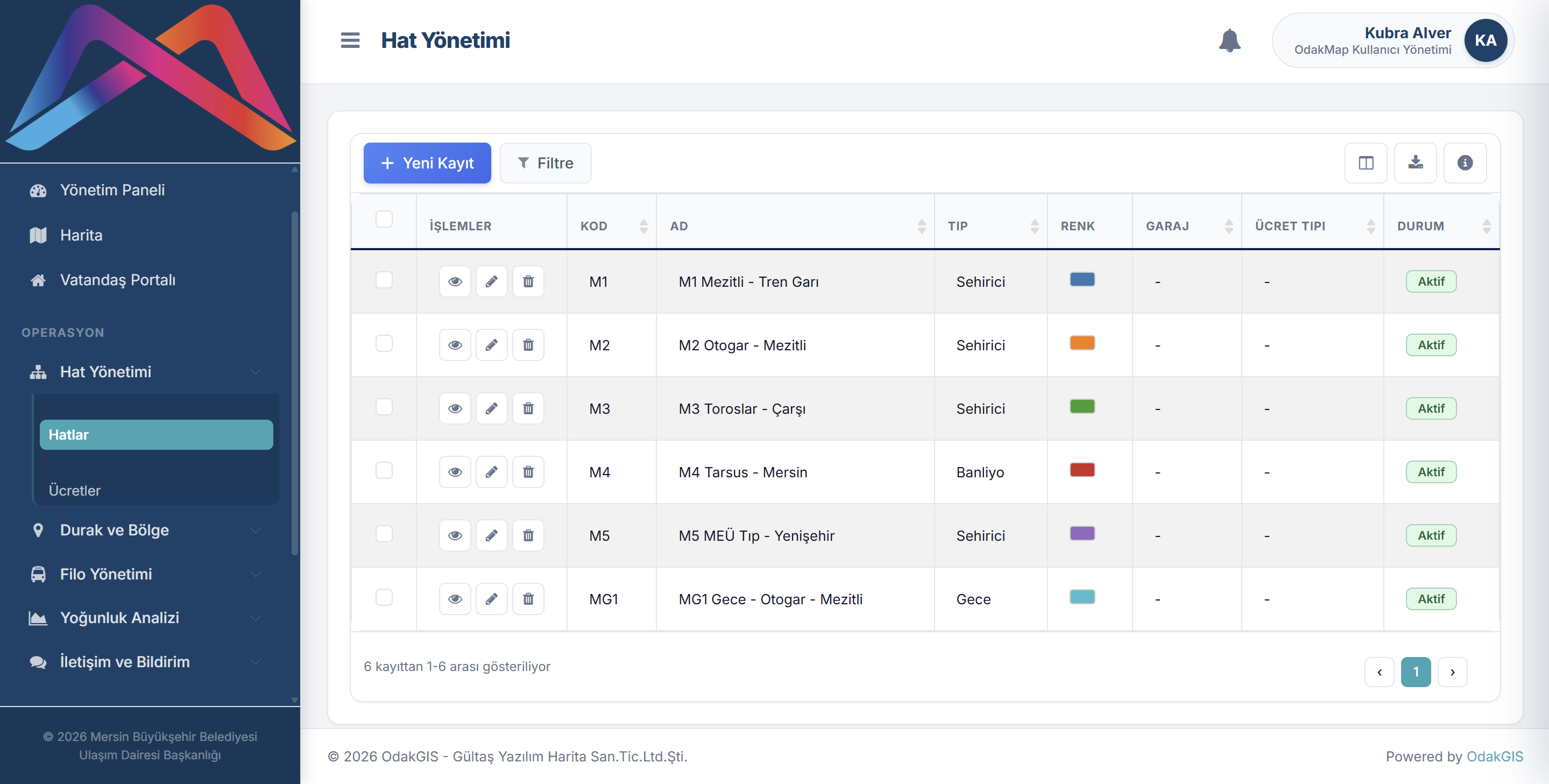
Line Management
The line management screen enables all lines to be listed with line code, name, type, color, depot, fare type, and status information. Adding new lines, filtering, viewing details, and editing are all done from a single table.
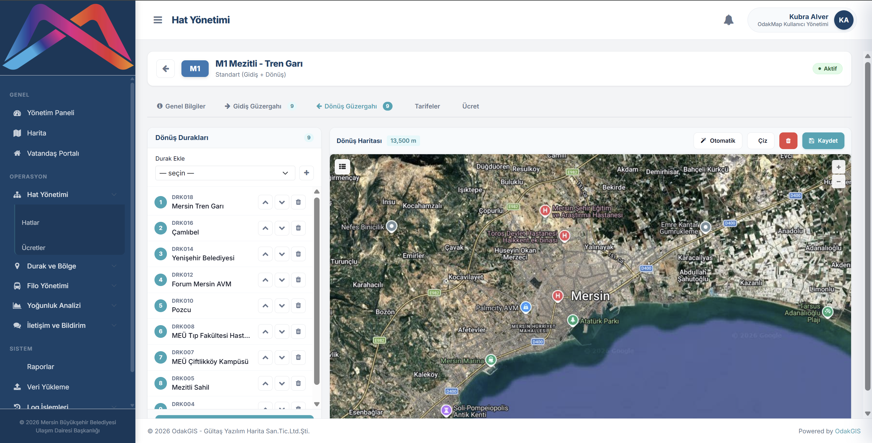
Line Detail and Route Definition
The new line / line detail screen manages the line definition holistically through the general information, outbound route, return route, schedules, and fare tabs. Line color, operating mode, starting depot, and status information are kept in the same form.
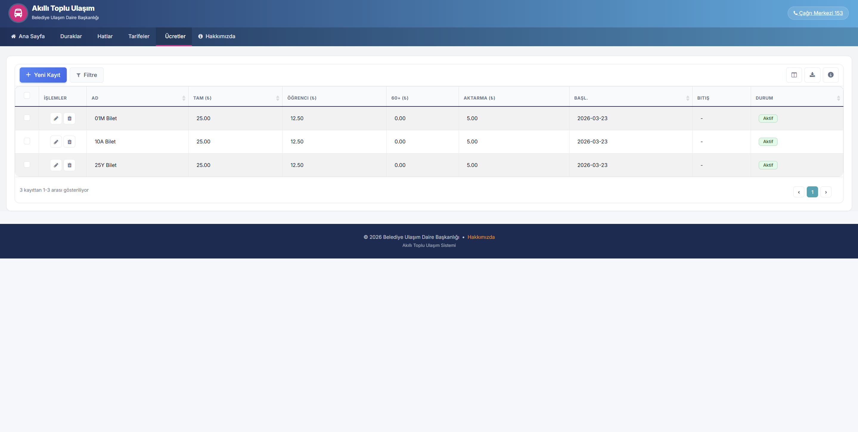
Smart Card and Fare Management
On the new fare type screen, basic information, validity start and end dates, and fare items for full, student, 60+ senior, and transfer are defined. Fare types work together with line-based tariff processes.
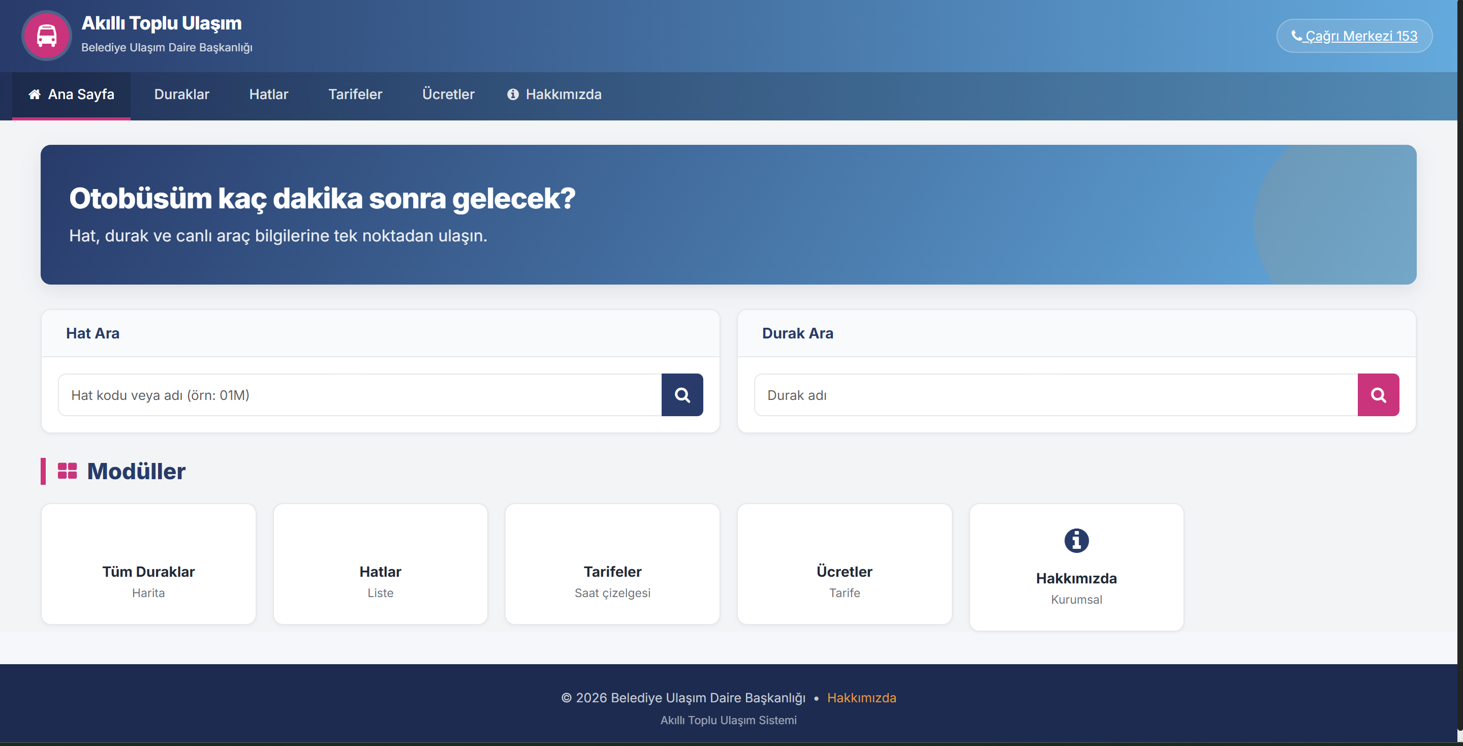
Citizen Portal (PWA)
The citizen portal home page offers line and stop search, modules, current announcements, frequently asked questions, and contact flows with a PWA-supported mobile experience. Citizens access live vehicle and stop information from a single point.
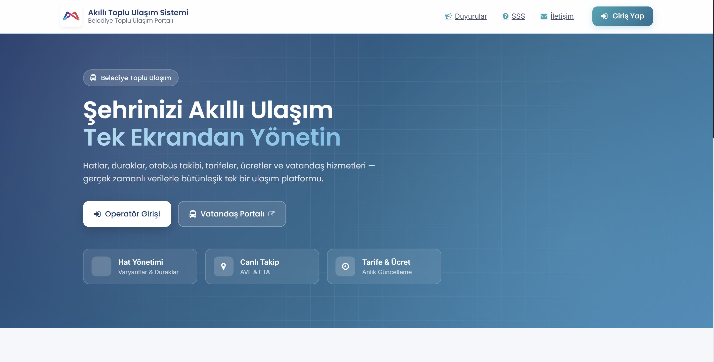
Operator Login Screen
The operator login screen includes username, password, remember me, language selection, and a secure session start flow. Municipal staff access the management panel according to their authorization level.
FAQ
Quick answers about Transportation Management System
The core use cases, technical infrastructure, and corporate value of the product are summarized here.
Contact UsTransportation Management System manages 20 modules on a single platform, including line and route definition, stop and zone management, trip planning, fleet and driver management, live vehicle tracking (AVL), estimated time of arrival (ETA), density analysis, smart card and fare management, citizen portal, announcements and notifications, dashboard, and reporting.
The system retrieves vehicle GPS locations from the Arvento AVL service via the HTTP pull method. The data received is broadcast to clients at 5–15 second intervals via the SignalR WebSocket infrastructure. Clients subscribe by line IDs and track only the relevant vehicles. The last location of each vehicle is kept in a separate table for instant querying.
The FrekansOneriWorker background worker analyzes the OD Matrix (Origin-Destination passenger flow matrix), passenger flow, card transactions, and AVL location history data. Based on peak-hour demand, capacity utilization, seasonal patterns, and weekly trends, it produces a comparison of current vs. recommended frequency; the recommendations are presented on the dashboard along with a score and justification.
The citizen portal works with PWA (Progressive Web App) support; it does not require downloading from an app store. The home page offers a quick-access panel, current announcements, frequently asked questions (FAQ), request/complaint submission via a contact form, institution information, and a PWA mobile browser experience. Citizen requests are submitted with SMS verification; up to 5 photos (10 MB) can be uploaded per request.
The following integrations are supported: Arvento AVL (vehicle GPS data via HTTP pull), Identity Sharing System — the SOAP service of the Turkish Directorate of Population and Citizenship Affairs, e-Government (Turkey’s e-Government gateway), SMS Service (HTTP-based verification and notification), VakifBank (payment gateway), External STS (Security Token Service — OAuth/SSO authentication), and GTFS (General Transit Feed Specification — international public transport data standard).
The system offers two-layer authentication with JWT Bearer and Basic Authentication (SmartAuth policy), corporate SSO integration via external STS / OAuth, role and permission-based access control, and a Personal Data Protection Law compliant audit infrastructure. Every entity change (add/update/delete) is automatically recorded with the old value, new value, user, and timestamp.
Backend ASP.NET Core 8.0 (C#) and Entity Framework Core 8.0; Frontend Angular 14+ (TypeScript) and ngx-translate; Database PostgreSQL and PostGIS; Real-time data broadcast SignalR (3 hubs: Vehicle, Density, Stop ETA); GIS GDAL/OGR, NetTopologySuite, and PostGIS; Map client OpenLayers and Leaflet; PDF generation DinkToPdf and QuestPDF. The system is deployed via a single docker-compose with a Docker container architecture; a reverse proxy (nginx / traefik) and 40+ configuration parameters are supported.
The system is deployed with a separate installation per municipality (single-tenant) model; each municipality’s data is kept isolated in its own instance. It is not multi-tenant; data is not stored in the software company’s database. All components are brought up with a single docker-compose structure; volume mounts are used for persistent storage. The port can be configured on 8089 by default.
All public transport operations of the municipality are managed through a single platform, providing a holistic view; managers can access KPIs such as the number of active vehicles, line efficiency, passenger density, and trip performance in real time via the dashboard. Developed on open-source technologies, the system offers a sustainable infrastructure without license dependency; geographic density data and OD matrices turn into a strategic data source for long-term transport planning.
Transportation Management System
Digitize Your Public Transport Processes,
Increase Control
Transportation Management System unifies municipalities’ line, stop, trip, fleet, live vehicle tracking, ticketing, density analysis, and citizen portal processes in a single corporate structure. It is an integrated smart public transport management system, GIS-based, developed on open-source technologies, and offered with a municipality-based single-installation (single-tenant) architecture.
GIS-Based Management
20 Modules
5–15 sec Automatic Vehicle Location Tracking
AI Frequency Recommendation
PWA Citizen Portal
General Transit Feed Specification Compatible
Open Source
Personal Data Protection Law Compliant